


The Geographical and Topographical Basis of Keyline
by the late Prof J. MacDonald‑Holmes, Dean of the Faculty of Geography, University of Sydney
The late Professor J. MacDonald-Holmes was Dean of the Faculty of Geography, University of Sydney and a truly great Australian. He followed the development of P.A Yeomans’ Keyline principles from their inception in the late 1940s.
Chapter I – “Yobarnie” and “Nevallan”
There is a farm better than most farms in the low hill lands of eastern Australia. Though located in a sparse rainfall area, it is free from drought and flood, the twin curses of Australia. There cattle grow fat, and a multitude of visitors flock to it as if on a pilgrimage.
To bring the reader into the picture, I would like him, before proceeding, to look carefully at these first photographs taken on this farm.
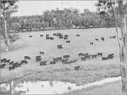
It is not usual to have such pasture in the winter-time in the Nevallan district. This picture, taken in the winter of 1960, shows how good the pastures were on Nevallan. In the background beyond the fence there are two belts of trees; the nearer was planted in 1953, the other in 1955. In the foreground is the top end of a large irrigation dam, most of which is out of the picture to the left.
page 1
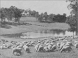
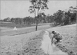
Upper. In the centre is a farm dam in a primary valley. There are trout in the dam and the water is used for irrigation. The tree belts in the background of the picture were what was left when the paddocks were cleared. A farm road lies above the uppermost tree belt.Lower. The walls of two farm irrigation dams can be seen in the background. In the wall of the nearer dam an eight-inch pipe at A is allowing water to flow along an irrigation drain. See also Plate 8, showing irrigation.
page 2
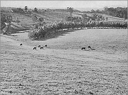
Only the lower three-quarters of this picture is Nevallan. Note the remarkable growth of the tree belt. These trees were planted as six-leaf seedlings in 1953, and at the time of the photograph (1960) were thirty-six feet high. The trees shown here are tallow-woods. They are not the fastest growing trees on the property. Spotted gums planted in 1955 are now taller.
There is a mature beauty in the landscapes shown in these four pictures. This is to be remarked upon because these landscapes have been created within eight years out of what was dry and almost barren land.
page 3
At first sight, this farm is unlike other farms, although there are fences, pastures, cattle, dams and trees. If we analyse these various scenes, we find that the property was not cleared in the usual manner; instead, belts of trees were left in certain places. For the most part, clearing of land in Australia has imposed uniformity over the landscape, and the detailed features have become subdued and smoothed out. But on this farm the belts of trees accentuate the features of the country by winding around the hills and valleys and down the slopes and spurs of the land. The patterns of fences and roads seem to be imitating the pattern of trees, and so do the wide, wavy stretches of lush pasture. The paddocks are not squared off and unrelated to the landscape.
page 4
These paddocks once held most unimpressive looking dirt – it could not be called soil. Now, despite an unfavourable agricultural climate, deep, dark soil supports the pastures, soil that was not there a few short years ago. How has this been brought about?
And the beautiful dams, there is something different about them. Their banks are grassed; the water is clear; there appear to be drains leading to the tops of the dams, and other but smaller drains coming out from the very bottom at the back of the walls of the dams.
It becomes obvious that these dams and their drains, with the trees, the fences and the roads, follow a pattern, and that the dams will readily catch any rain run-off from the hillsides. The larger taps, or valves, at the back of the dam and apparently placed in the smaller drains, allow water to flow out of the dams, around the ridges and valleys, and down the slopes.
Here, on what were barren, eroded slopes and deeply gullied valleys, which earlier were thought to have no water resources for such purposes as irrigation, there is now a large area of irrigated land which covers almost half of the entire property. Most of the water comes from that which actually falls as rain on the property.
This farm has been especially and uniquely planned to be secure against drought and the occasional, but severe, heavy flood rains which together cause Australian farmers to lose millions of pounds each year. This farm has been planned and developed to yield lush pastures in summer and winter, to hold abundant water for stock and irrigation. It is designed also to have trees for wind breaks to protect the land and the stored water from hot drying winds and to shelter the cattle against the cold winds of winter and the exceptionally hot winds of summer, thus benefiting their constitution and bettering their condition for markets.
page 5
This farm belongs to Mr P.A. Yeomans, and is the home farm of Keyline. Situated at North Richmond, New South Wales, it lies on the outer edge of the County of Cumberland, the county which includes the city of Sydney and the surrounding country. The farm is divided into two parts, one called “Yobarnie” and the other “Nevallan”. They look different and are very markedly so, because of their history and the way they have been worked. And so they will be referred to as district entities.
When we look into the development of this combined farm, we find many contradictions against conventional agricultural practices. For instance, the many clovers and grasses of the pasture appear to be in extraordinarily good condition. The green of the grass is healthy looking and the soil beneath the pasture is almost black. It could be thought that the soil was always like that, and that artificial fertilizers have been used profusely, but such is not the case. These orthodox aids to good pasture have been sparingly used, and only for the initial sowing of the seeds of grasses and clovers. The finest pastures on these properties have had only one hundredweight of superphosphate per acre, which was sown with the seeding eight years ago. This amount could be considered ridiculously low for such country, when orthodox recommendations for much better land than this would be a minimum of one hundredweight of superphosphate per acre each year.
Since these properties were first cleared and occupied early in the history of New South Wales, they have for over one hundred and fifty years been examples of woefully deficient pasturage, mainly because of low rainfall, poor soil and inexpert methods of farming. But a great change has taken place.
page 5–6
What was once almost dry land has now an amazing development of water resources. Likewise, the once shallow and poverty-stricken soil and poor pastures have been changed to deep, dark, fertile soil, and high-quality forage for cattle production.
This has been achieved through ideas and methods that are quite outstanding but unorthodox. The properties of Yobarnie and Nevallan are Keyline-developed farms and were the forerunners of what is now an accepted farming system. My task is to describe why these two farms are so unique and to relate some of the history that lies behind Keyline.
Chapter II – The Importance of Land Surface Shape
An “Eye for Country”
The greatly changed landscape was not all improved at once. The owner had to reach out for a new appreciation of land shape, in detail, and over the whole large property. Geographers, engineers and all scientists who work with land must first appreciate and understand the meaning of land surface shape. They must have “an eye for country”.
Every landscape consists in the first place of a series of small valleys, each a small water catchment. In turn, these combine in regular pattern to form a major catchment. Keyline “eye for country” begins with this first feature of the landscape – the smallest valley. Because it is of first importance, it is called the primary valley. Surrounding this small valley is a neutral area, so far as water flow is concerned, which separates one primary valley from the next. This neutral area of no water flow, a ridge, has been called the primary ridge, and the whole combined – primary valley and the portions of the two adjacent primary ridges – becomes a primary land unit, and an entity by itself.
page 6
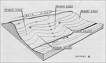
Beyond this primary land unit there is another primary valley and its primary ridges, and probably several more. Arising out of the heads of the primary valleys and surrounding them there is a ridge or water divide, called the main ridge. The main ridge divides one series of primary valleys and primary ridges from another. The most significant aspect of this analysis is that it involves a pattern, a recognition that smaller shapes are integrated to form a larger whole, and that this pattern might be repeated several times on a single medium-sized property.
page 7
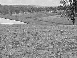
The dam on the left of the picture is at an intermediate height in a primary valley. Above it, out of sight to the right of the picture, is another dam higher up on the Keyline of this valley. The small valleys indicated by the two drain lines are too small for dam construction, but beyond them is another primary valley containing three dams for irrigation water.
Each primary valley changes its slope perceptibly at a point where rain run-off from the valley sides would collect together to form a small stream or torrent. As one proceeds up the main ridge, each primary valley’s collecting point is higher than the collecting point of the primary valley below. A line joining these points would rise as it progressed upstream.
On Paper
Not only must land scientists and farmers have an eye for country, they must also “see” their land on paper, since working on land and planning on paper must be performed together systematically. The best way to show land shape on paper is by means of a contoured and scaled map.
page 8–9
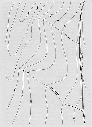
Contours on paper represent horizontal lines on the ground, or better still, outcrops of horizontal surfaces on a slope. One can appreciate the shape of land from a suitable contour map much better and more readily than from an examination of the land itself. Although these lines appear to be indiscriminately spread, this is not so – they follow very definite natural patterns. Within the pattern of these contours lie some of the secrets of Keyline, a unique method of land development and improvement originated by P.A. Yeomans.
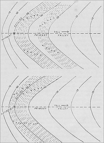
The word “Keyline” also designates a particular line. A careful scrutiny of a piece of farm land shows that in each small primary valley there is a point which separates the steep head of the valley from the more gradual slopes at its foot – the point, named by Yeomans the Key point, at which the valley first flattens out. A line through this particular point of the valley on a true contour, or in actual practice at a slight gradient, is called the “Keyline of the Valley”, hence the name applied to this whole method of farm planning and development.
page 9–10
This “Keyline of the Valley” does not apply to rivers or creeks, large or small, but only to the smallest valley of all – the smooth-bottomed valley which a farmer can work with his implements. This alone has a Key point and Keyline.
For a primary valley to be a valley it has to be contained; that is, there must be a ridge on either side to give the valley its form. These primary ridges and primary valleys are classified in Keyline as the smallest units of land shape. Practically all agricultural land consists of these two shapes, plus the larger main ridge rising above them and out of their upper portions.
page 10–11
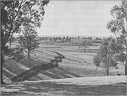
In the foreground the overlapping spurs indicate the shape of a primary valley leading into the secondary. In this secondary valley there are three Keyline dams and three other dams. The photograph was taken from a main ridge, which swings around and comes into view again in the immediate background.
There are occasions where a series of primary valleys will mould into a single valley which is itself not a valley of a creek or river. This valley has a rounded or grassed floor similar to that of the primary valleys. It is called a secondary valley because it is the second analysis of the valleys of the landscape. The secondary valley too can have a Keyline. Land has another dimension, namely length. Standing on the main ridge and looking along a primary ridge towards the creek below, this distance is called the “length of the land”. This length on Nevallan is four hundred yards; on Yobarnie it is longer, while on the gently-sloping country of western New South Wales it can be five or more miles.
page 11–13
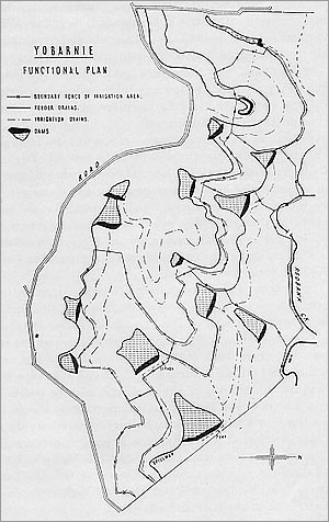
Where the development of water resources warrants the construction of farm dams for irrigation, it may be possible to locate dams on the Keyline of these primary valleys in such a manner that one dam would overflow, by means of a suitably sited drain, into the next dam in the neighbouring valley – keeping all run-off water from the high country high on the property. It is the recognition of this geographical setting of the primary valleys, the primary ridges and, on occasion, the secondary valleys, with their Keylines and Keypoints, that enabled Yeomans to see immediately the tremendous significance of this pattern in his plans for total land-resources development.
page 13
Chapter III – What Keyline Planning Is
Keyline planning envisages firstly the discovery and then the development of every natural renewable resource of the landscape in order to produce a state of balance which will be in conformity with land shape, climate and soil. The basic idea is to make nature assist the farmer instead of his engaging in conflict with nature, to his economic loss.
There was a “balance”, a slow rate of change, in the Australian landscape which preserved it from violent change until the early settler altered it and threw it out of balance, eventually causing more or less serious and widespread land deterioration and soil erosion. What the farmer and grazier need is not an unstable landscape but a permanent and improving one.
page 14
In the case of Yobarnie farm, Yeomans early recognized from his work that the division of the landscape into primary valleys, primary ridges, main ridges, and secondary valleys, as he named them, was fundamental. He also recognized that there were individual Keypoints in every primary valley, and that a succession of primary valleys as one moved up the main ridge would have Keypoints at progressively higher levels. He saw that lines for feeder drains, really extensions of the Keylines of the valleys but leading from the high country, could control the run-off from this high country so that no water would be wasted to lower levels before all the high dams were filled. Yeomans called this the Keyline because he believed it would be the key that would unlock every problem on the property.
page 15
In land development the contour map is used for planning in general, as in locating Keypoints, Keylines, and suitable shapes for possible dam sites, singly and in series. The contour map is primarily a planning map, and although it can be useful for specially recording work carried out on the property, it is not a substitute for levelling, drain grading, and so on. The genius of Keyline designing is the matching of almost contour Keylines to the actual contour lines of the primary and secondary valleys, and matching extensions of the Keylines to the related ridges throughout the whole landscape. This in effect makes Keyline arithmetically correct and sound in principle, and it integrates the smaller land units, on the ground and on paper, systematically.
page 15–16
Chapter IV – Other Factors of Geographical Importance
There are several other important fundamental geographical factors in land-resources development. There is a relationship between precipitation and water flow, and between soil erosion and water flow. The location of dam sites, the supply of material for dam building and the location of suitable area for cultivation and irrigation are all dependent upon the past denudation history that placed deep soil forming deposits on the middle slopes.
The most fundamental of natural processes is land denudation. Relentlessly, the elements disintegrate rock surfaces, transport the debris to lower levels and eventually deposit it in the sea. Rain run-off will collect in each primary valley on the upper middle slope and will begin to cut into the soil and erode it away. It is significant that at these water-collecting points, past denudation forces have left soil-forming deposits deeper than elsewhere up or down the slope – suggesting a site for a farm dam and protection against loss of both soil and water.
page 16

The photograph was taken in December 1957 at the end of a severe drought period.
Then there is the important matter of clearing land. Wind breaks and tree barriers would have been of economic advantage and likewise would have protected wild life, nature’s helpers against insect pests. Australian rivers are now rising higher with flood rains, but they are retaining their water flow and volume for shorter periods than in times past – attributable, I believe, to wrong methods of land clearing and farm management, and also to the quick run-off that comes from roads and streets.
Keyline has an additional contribution to make. Chains of high level Keyline dams, creek dams and other types of dams, together with Keyline irrigation, tree clearing, and hillside tree planting, are lessening the flood water entering our larger rivers. I am of the opinion that the strategically-planned farm dams of Keyline in increasing abundance on our sloping country must eventually make a major contribution to flood mitigation.
page 17
page 18
Chapter V – The Geometry of Keyline
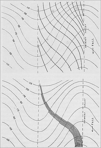
The system of cultivating land perfected by Yeomans involves another important factor, namely the geometry of Keyline. This is based on the various patterns made by contours on the land, which are consistent to a marked degree for each of the shapes classified in Keyline.
Heavy rain will at times cause water to flow over practically the whole of the land surface, and the movement of water is by the most direct downhill path from the primary ridge to the valley below it – at right angles to the contours. Any abundant run-off rain water will remain for a longer time on the primary valley section than on the primary ridge section, so the valleys receive much more moisture than the ridges. The resultant effect in the natural landscape is for the ridges to dry out quickly while the valley remains moist or even wet.
Keyline Cultivation overcomes this natural flow pattern of water on land, holding the water on the ridges longer, and thus evening up the moisture content of the soil as between primary valley and primary ridge. Keyline cultivation offers a solution by altering the natural path of water to make the first run-off move to the ridge, away from the valley floor.
page 19
page 20
Reference to the contour diagram of a primary valley shows that along the Keyline of the valley the contours are closer together in the centre of the valley than out to the sides; but below the Keyline, the contours are farther apart in the bottom of the valley than a little distance out. To cultivate this valley so that the first flow of water will spread wider and move outwards from the valley bottom, it is only necessary to cultivate parallel to the Keyline up the slope.
The second shape of the land, the primary ridge, has steeper sides than its centre. If a contour line, or a line with a slight grade, is used as a guide line and cultivation proceeds up the slope from this line and parallel to it, the parts of a furrow on each side of the ridge will be higher than at the centre – so water will drift towards the central portion of the ridge. This pattern ploughing of Keyline is so effective that the primary ridge and primary valley shapes on the Richmond properties appear equally well grassed and have the same moisture content.
page 21
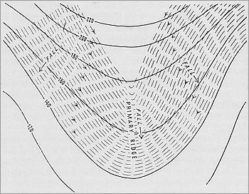
To obtain this pattern of ploughing, the chisel plough is used extensively. Its scratch-type cultivation does not invert the top “live” soil as conventional mouldboard and disk ploughs do, instead promoting the entry of rain water and air into the soil and, combined with greater soil depth, increasing its fertility.
Compaction of soil is so universal on our farming and grazing lands that the chisel plough alone is almost always beneficial – but when coupled with Keyline cultivation on pasture land at the proper time of year, once each year for the first three years of development, it has the rather magical property of rapidly increasing the depth and fertility of some of the very poorest soils.
page 21–22
By providing a better utilization of moisture on the ridges, the valleys are safeguarded because they are better able to absorb the reduced run-off. This is controlling a water resource scientifically, and for similar reasons the hazard of major soil erosion is eliminated, since the need for purely protective measures is entirely removed. This is in open contradiction to older, now out-dated methods of holding the soil by expensive protective structures such as contour terraces and grassed outlets. Keyline is control.
page 23
Chapter VI – Farm Dams and Keyline Pattern Flow Irrigation
Since most soils in Australia are lacking in water, it becomes important to make more rainwater penetrate and sustain more moisture within the soil, thereby extending the growing condition longer than could previously be expected. The point at which control can be exercised best is at the Keypoint of each primary valley, especially where the upper valley’s shape lends itself to storage of water in significant volume. By using a chain of Keyline dams situated at topmost levels and constructed to overflow from higher to lower, valley by valley, water is maintained at a higher elevation on the property, and therefore is more valuable than if allowed to spill into a lower dam in the same valley. The fall to get overflow water from one Keyline dam to the next, sideways as it were, may be only one to three feet, whereas the fall from a higher to a lower dam in the same valley will be ten to forty feet or more.
page 24
On Yobarnie it has been possible to have dams at three levels: firstly two chains of dams at Keyline levels; secondly another chain at a lower level, using water which originates outside the property and would otherwise run to waste; and thirdly, pumping dams at points where excess water flowing from above would leave the property. When all the dams are filled, the total area of land covered by water represents about five per cent of the property. When all this water is used for irrigation, about fifty per cent of the property is irrigated effectively, in rotation over the years.
The overall spread of the cost of dams etc. throughout Yobarnie and Nevallan amounts to about twenty-five pounds per acre of irrigated land. Other Keyline-planned farms may show costs of fifteen to fifty pounds per acre, depending on land shape and climate.
page 25
page 26
page 27
Yobarnie and Nevallan last winter carried one bullock to two acres, and with the whole plan approaching completion, were expected to carry three bullocks per irrigated acre with the on-coming hot weather.
Keyline dams, placed at the highest point in the primary valleys where water can be stored economically, invariably have land below the level of the bottom of the dam, which can be watered quickly and at low cost by Keyline pattern irrigation. Beneath the wall of the dam, at its lowest level, there should be a pipeline containing a screened inlet on the inside and a valve at the back, so the water can be turned on and off like a kitchen tap. Our present experience in Keyline indicates that an eight to ten inch diameter pipe is adequate and efficient.
Yeomans has found it necessary to reconsider the techniques of laying pipes in dams to prevent seepage, and has labelled this the lockpipe system: locks or barriers along the length of the pipeline prevent water movement along the outside of the pipe, strengthening the dam wall and eliminating a common cause of failure.
page 27–28
Keyline pattern irrigation also depends on the location, design and construction of the irrigation drain. When the lockpipe valve is opened, water enters a drain built at a set grade in the down-land direction. During irrigation the water is blocked with an easily manipulated stop called an irrigation flag, made of fabric, which forces the water to build up and flow over the lower lip of the drain along a selected portion of its length. Three or more flags are used in sequence, causing the spill-over point to move progressively along the drain – watering many acres each hour without any need for pumping.
Keyline pattern irrigation depends thirdly on Keyline cultivation patterns, which have already been used to control and spread the water rapidly but gently across and down the slope.
page 28–29
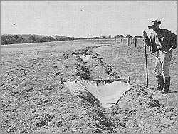
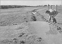
Upper. An irrigation drain with two flags in position and in readiness to hold the flow of water.Lower. The flow of water from the dam, moving along the drain under gravity, has reached the first flag, filled up, and commenced to flow over the lip of the drain. In Keyline, all fences have to be carefully placed in relation to water collection and distribution.
page 30
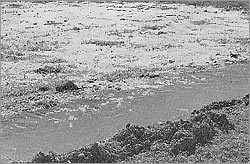
Upper. The length of the spill in the drain is fifteen yards, and the water has moved down the slope sixty yards and across the slope forty-five yards. This irrigation took eight minutes from the time the water started to spill, owing to prior Keyline pattern cultivation.Lower. The phenomenal growth of vegetation in a paddock eaten off eleven days earlier and then re-irrigated.
page 30–31
Where dams have had to be placed low in the landscape without sufficient area below for flow irrigation, a medium-head, large-flow-volume pump lifts water from the lockpipe valve to an irrigation drain placed higher up. In the twenty-six-inch rainfall country of New South Wales, gravity irrigation may be done five to nine times a season, laying to rest the risk of flood and drought and guaranteeing security for any farming and stocking policy at very reasonable cost.
page 31–32
Chapter VII – How Keyline Evolved and My Association With It
Keyline ideas and practices were not a sudden discovery, but the result of a long period of trial and error – testing of ideas and methods, the training of personnel and the finding and developing of the right machinery to do the various jobs efficiently and economically.
page 32–33
In the late 1930s the Department of Geography of the University of Sydney decided to make a major land-use survey of the Tamworth region of New South Wales, funded by the Carnegie Corporation of New York. During the survey I became very interested in the problems of soil erosion, which were receiving very little attention in Australia at the time. In the dry climate of New South Wales it was necessary to keep as much water as possible on the land, rather than draining it off as U.S. schemes of the day advocated.
page 34
I later published a book, Soil Erosion in Australia and New Zealand. Before it was finished, I had become associated with P.A. Yeomans, who had started work on the Yobarnie section of his property after purchasing it a year earlier, shortly before a disastrous bushfire swept through Yobarnie and the foothills of the Blue Mountains in December 1944, leaving the land in very poor state.
As a mining man, Yeomans had become interested in the problem of soil erosion he had seen on many farms. He invited the heads of the recently-formed Soil Conservation Department to visit, but considered their comments negative and pessimistic, and decided to proceed alone with a policy of holding, storing and using for irrigation as much run-off as possible, rather than simply disposing of it.
page 34–35
Hearing of my interest, Yeomans invited me to Yobarnie early in 1945. Following the fire, the paddocks were bare and hard. When high wind and heavy rain followed some weeks later, two of the dams were completely filled with ash and debris. Gullies were smoothed and holes filled in; contour terraces were cut and graded to allow water to flow into dams already equipped with four-inch pipelines beneath the walls – a forerunner of the present lockpipe system. During that year and the next, about twelve or thirteen irrigation dams were constructed.
page 35–36
Evidence of the large amount of work done was recorded by Adastra Airways in 1948, showing the property covered with grassed feeder drains to the many irrigation dams. Yeomans experimented extensively with spray irrigation, laying six-inch asbestos cement mains a mile and a half from a ring dam constructed on the main ridge of Yobarnie, and adding large monitor-type spray-head stands in 1947, each watering over an acre of ground.
page 36–37
It became evident to Yeomans that spray irrigation for pasture in beef cattle production, without a good rain pasture to back it up, was not economically attractive. Pastures, despite conventional fertilizer use but without irrigation water, failed to persist. It was realized that much more moisture had to be taken in by the soil.
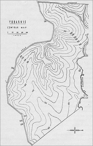
In the same year Yeomans constructed the first version of the chisel plough he was to use on the property. I decided that a contour map could help him, and with members of the Geography Department, including senior students, the map was completed – a map which has proved over the years to be very accurate and remains still the basis of all paper planning of Yobarnie and Nevallan.
page 37–38
Following the mapping, we used a large crawler tractor and heavy construction ripper to deeply rip up several acres. When heavy rains came, the deep contour rips trapped the water and the place was soon covered by tall green grass; over the next year or two, seven hundred acres were treated this way. We also began “contour strip clearing”, leaving strips of timber on the contour when clearing the back paddocks, and published an article on the “Yobarnie methods of soil and water conservation” in the Australian Geographer, Volume V, No. 8, 1950.
page 38–39
Very heavy rains occurred in January 1949. On one weekend six inches of rain fell, and on the Monday morning four and three-quarter inches fell in less than an hour. Both a dam under construction and an older one just below it broke through. Yeomans immediately began replanning the dams to be built higher on the slopes, and decided that future dams should be built to the estimated maximum rain run-off rather than the usual practice of designing to minimum annual run-off.
page 39–40
The first ideas of Keyline grew out of Yeomans’s critical observations of the results of this earlier work. One paddock sown with peas and sudan grass ploughed in with a disk implement failed to change the soil’s texture or colour, while a paddock of poor natural pasture that was chisel ploughed, followed by rain, showed a rapid change in soil colour and texture. This soon deteriorated again, but Yeomans recognized that if this rapid soil change could be repeated several times on poor soil, it might be induced to persist – giving him a technique for developing a really worthwhile rain pasture.
page 40
Then it was Nevallan’s turn – poorer and more difficult to plan than the smoother landscape of Yobarnie, with a sea of old firewood stumps. Fortunately Yeomans’s redesigned chisel plough, given a new resilience instead of a rigid build, proved successful, and after two to three years of Keyline cultivation, even stumps too difficult for a bulldozer were eased out of the ground with the chisel plough and a small tractor.
page 40–42
On Nevallan, a three-year “course” of Keyline cultivation – simply the cultivation of development pasture paddocks each autumn for the first three years – developed an extraordinary depth of dark soil teeming with life. The original Keyline area of Nevallan can now carry a bullock to the acre of improved land throughout winter, more than ten times what the land could originally carry, having been considered practically worthless.
page 42–43
Yeomans and I were among the first to apply orthodox American soil conservation methods extensively in Australia, and he spent a good deal of money undoing the banks and drains of that earlier work as Keyline developed. We had always agreed that in an agricultural climate of only twenty-six inches or so of rain a year (dropping to seven inches in one particularly dry year), it would be necessary to hold every drop on the property, and our planning was always based on using this water rather than getting rid of a surplus.
page 43–44
The earlier dams, with their small pipes, were completely emptied and drained, and a large cut was made through each wall to lay the new, larger pipe of the lockpipe system. Just as the primary valley fits into its place with the main ridge and the primary ridges and other primary valleys, so the farmer, having planned overall, can start with one unit of his property, and advance once it becomes profitable – a bit at a time is the way to successful accomplishment, but Keyline plans the lot before starting.
page 44–45
Keyline overall planning has a new psychology: its approach to land is no longer the idea of conservation. The object of Keyline is development rather than protection. Soil conservation is stagnation, and may even be retardation. Land is to be lived on and enjoyed, not lived off and destroyed by wrong practices in an effort to gain a precarious livelihood.
page 45
Chapter VIII – My Assessment of Keyline
During the early years of the development of what I once called “The Yobarnie methods of soil and water conservation”, large numbers of visitors came to the farm. It was not until August 1952 that there came an opportunity to make a large public display of the new principles and practices of Keyline, when two large parties – the A.N.Z.A.A.S. Congress and a group from the State Liberal Party’s Rural Movement – visited the property together.
page 46
Farm walks were instituted for Sunday afternoons, drawing visitors from all over Australia and from other parts of the world. The first Keyline book, The Keyline Plan, was written by Yeomans in 1954, with an edition of ten thousand copies – uncommonly large for an agricultural book. It soon went out of print, and Yeomans decided not to publish a second edition, considering a more complete exposition necessary.
page 47
Yeomans had, from the start in 1943, been searching for a method of designing land development on paper so a plan could be taken away by a farmer, engineer or agriculturalist and set up directly on the land itself. He told me that the contour map produced by the Geography Department received more study and consideration than any plan he had ever produced in his engineering businesses.
page 47–48
Yeomans’s second book, The Challenge of Landscape, was completed in late 1957. I had the opportunity of reading it in manuscript form, including the notable chapter on the “Keyline Scale of Permanence”, with succeeding chapters on Climate, Land Shape, Water Supply, Farm Roads, Trees, Permanent Buildings, Subdivision Fences and Soil. The book was published just before Yeomans left with his wife and youngest son on an overseas tour, comparing his theories with agriculture in Europe and North America.
page 48
Yobarnie remains to me the most remarkable property in Australia, having been the subject of longer study of farm water resources development than any other I know of. Many farmers who have visited are reorganising their own properties on Keyline, and companies interested in land development have begun applying these methods too.
page 48–49
I have written this book as a geographer, in support of Yeomans’s geographical analysis of his problems, and have refrained from detailed discussion of the biological, nutritional and health aspects of Keyline, which are themselves of tremendous significance. A full exposition is available only in Yeomans’s own book, The Challenge of Landscape.
It is surprisingly difficult to break through the wall of prejudice surrounding conventional agricultural practice, yet Yeomans has anxiously and pragmatically offered to permit any scientific and economic investigation of Keyline, and would actively support such tasks. He claims he can show rational proof of all aspects of Keyline planning, though full scientific proof is outside his own field – a task he believes belongs to the appropriate scientific authorities, given the parlous condition of Australian rural development at the time.
page 49–50
Yeomans claims to have made deep, dark, fertile soil over hundreds of acres that were originally poor, grey, shaley soils, or worse. The commonsense proof, he suggests, is to seek confirmation from people who knew the earlier condition of Yobarnie, then dig up the present soil with a spade and see its condition now.
Much controversy has arisen over methods and purposes of farm-developed irrigation in low rainfall areas. Irrigation methods suitable to humid areas, where “supplemental” irrigation overcomes short drought periods, are wrong in principle when applied to low rainfall areas. For these, Yeomans has demonstrated that the best system involves full utilization of all the water resources of a property, especially one with long, gently undulating slopes.
page 50–51
On the remarkable growth of tree belts planted on Nevallan, the obvious check is with the New South Wales Forestry Department, from whom the seedling trees were purchased. It is well known that white clover does not normally grow in the poor shale-derived soils of the outer County of Cumberland except under heavy artificial fertilizing and irrigation – yet on Nevallan and Yobarnie there is abundant growth of white clover throughout, irrespective of irrigation. This should be substantiated by outside scientific observers.
Because of this soil transformation and the public acclaim Keyline has received, it is in the national interest that a major investigation be undertaken, potentially reorganising State Conservation Departments to focus on development rather than conservation.
page 51
It has been my privilege to have been associated, at times very closely, with P.A. Yeomans in his early experiments on soil and water conservation and spray irrigation, and subsequently in his constructive methods of Keyline development. My own reversal of opinion – from soil conservation to Keyline construction – is as definite as is P.A. Yeomans’s own.
Of course, there is much more to be written about Keyline. I hope one day to write the full story of Yobarnie itself, and illustrate its complete and dramatic transformation by the planning and development methods of Keyline.